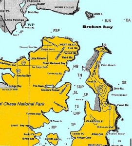
The following are the descriptions of the Rounding Marks and Buoys that are used in the Club’s Race Programs with a map indicating their positions.
BJN – Barrenjoey North – Orange PBYC buoy 1 nm due North of Barrenjoey Lighthouse.
FL – Finish Line – Between the signal mast of the Committee Vessel normally moored to the east of Portuguese Beach and an Orange PBYC buoy moored nearby, crossing from the direction of the last mark.
FSP - Flint & Steel Point – Yellow conical Waterways mark situated 0.5 nm (approx) east of Flint & Steel Point.
JP - Juno point – Located just East of Juno Point
Ll - Lion Island – The summit of Lion Island.
MB – Mackerel Beach – Yellow conical Waterways mark situated east of Great Mackerel Beach.
OA – Ocean A – Location: 33 deg 33.000 S – 151 deg 23.000 E ( approx. 2 nm east of BJN). Indicator buoy may be at that location
OB – Ocean B – Location: 33 deg 36.500 S – 151 deg 21.000 E (approx. 1 nm east of Little Head). Indicator buoy may be at that location
PB – Palm Beach – Orange PBYC buoy situated NWest of Sand Point at Palm Beach
RP – Rocky Point – Yellow conical Waterways mark situated between Rocky Point & Woody Point.
SDP – Soldiers Point – Yellow conical mark southeast of Soldiers Point.
SL – Start Line – Between the signal mast of the Committee Vessel normally moored to the east of Portuguese Beach and an Orange PBYC buoy moored nearby, crossing in the direction of the first mark.
SP – Stokes Point – Yellow Waterways mark situated approx 200m north west of Stokes Point.
TN – Twilight North – Orange PBYC buoy west of Sand Point.
TP – Taylors Point – Yellow conical Waterways mark situated northwest of Taylors Point.
TS – Twilight South – Orange PBYC buoy east of Longnose Point.
WP - Walker point – Located just East of Walker Point


